
Your Cart is Empty

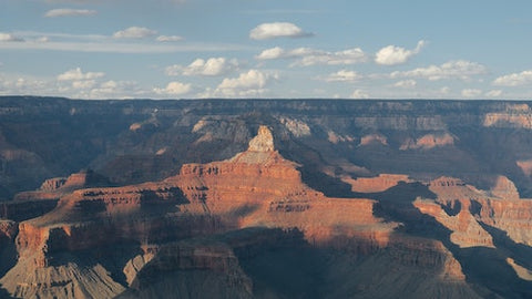
No doubt about it: the Grand Canyon is a bucket list location if there ever was one. The breathtaking scope of the park, the dramatic rock formations and cliffs, and the whitewater rapids at the bottom make it one of the most iconic locations on Earth. So, what is a backpacker like yourself to do with this park? Hike it, of course!
This list of the five best day hikes in the Grand Canyon will help you plan out your expedition. We've organized the list by difficulty from relatively easy to more strenuous. Some of the hikes are we mention are pretty intense, but they are doable for a day hike—which for us is anything less than 25 miles, the distance we recommend a decently fit person could hike in a day without intense training.
Other hikes on the list are much shorter and are better for sightseeing than hardcore hiking. No matter what, though, every hike on this list—and in the Grand Canyon—is filled with insane views and epic miles!
Let’s get started.
Distance: 9.1 Miles
Elevation Gain: 1,000 feet
Difficulty: Easy-Moderate

This trail is relatively flat for the Grand Canyon and is the easiest trek on our list. Don’t let that stop you from checking it out, though, because the views are simply superb.
Widforss Trail will take you through the forest along the edge of the North Rim, giving you a truly unique experience of the Grand Canyon with fewer people and less of a “dry desert” feeling. This is a great hike for people who like to take their time or be alone. You should have most of the trail to yourself, and a full day’s hike of this trail gives you ample time to wander and explore.
This is a great trail to warm up with; if you’re spending a few days at Grand Canyon National Park, starting with Widforss Trail will serve as an excellent warm-up trail to get you prepped for the other tougher, high-elevation hikes at the park. No matter what your plans are, though, this North Rim day hike should always be on your list.

Distance: 5.6 miles
Elevation Gain: 2,000 feet
Difficulty: Medium

This hike is along a gorgeous portion of the ever-popular South Kaibab Trail. Though it’s less than 6 miles long, you’ll be plenty satisfied (and plenty tired) by the end of it. This trail takes you through some of the Grand Canyon’s best lookout points; one of them is literally named “Ooh-Aah Point.” If that doesn’t tell you this hike is worth it, we’re not sure anything will.
To hike this trail, you’ll have to park at the Grand Canyon Visitors Center and grab a shuttle for the 10-minute ride to the trailhead. Of course, you could walk that distance if you prefer to rough it, but the views are better on the actual trail. Starting from the South Kaibab trailhead, you’ll trek along the South Rim marveling at spectacular views from start to finish. There won’t be much camping on this trail, so you can leave your backpacking tents behind to save some weight.

Distance: 12.2 miles
Elevation Gain: 3,156 feet
Difficulty: Moderate
Plateau Point is a lookout where some of the most incredible views in all of Grand Canyon are located. The entire park unfolds right in front of you as you reach the lookout point, and the sheer size of the canyon really becomes clear when you can strain your neck left and right and still not contain the whole of it. Because of this trail’s incredible views, it can get pretty crowded, so make sure you head out early to avoid the foot traffic.
Starting at the Bright Angel Trailhead (very close to the parking lot at Grand Canyon Village), walk until you reach the Indian Garden Campground. There the trail will split: Bright Angel going right and Plateau Point to the left. Take the left fork and walk a few miles more until you reach Plateau Point, a spectacular lookout at the very edge of the South Rim.
Trekking there isn’t difficult, but leaving is—not because of the trail itself, but because the views are so insane you’ll have to drag yourself away. Right in front of you (well, 4.2 miles away, but it’s massive) is the iconic Buddha Temple, the mountain you’ve seen a million times in pictures. Being there, though, is nothing like the pictures. It will absolutely take away whatever breath you have left in you after the hike.
This is likely one of the best South Rim day hikes in the Grand Canyon for people who are beginner backpackers or those who don’t feel fit enough to truly conquer the deep parts of the canyon. The elevation is tough but not exhausting, the trailhead is very close to civilization, and the views are some of the best you’ll see anywhere on Earth (much less the Grand Canyon). Plus, there are a few stops along the way where you can rest, fill up your water bottle, and even use the restroom. It’s still worth it for seasoned hikers, too, simply for the spectacle and the undeniably amazing view from Plateau Point.

Distance: 17.7 Miles
Elevation Gain: 5,626 feet
Difficulty: Very Hard

This trail is not for the faint of heart, or the slow of feet. If you want to make this a day hike, you’re going to need to be in serious backpacking shape. Even for seasoned thru hikers, 17.7 miles in one day is a lot, but it is doable. The Boucher Trail also makes an excellent overnight hike, so bring your tent, light sleeping pads, and lightweight down sleeping bag in case you want to take things at a more leisurely pace.
This trail is a great way to experience both the incredible heights of the South Rim and dipping your feet in the Colorado River on the same hike. A few miles from the trailhead, the trail joins up with Boucher Creek, which flows all the way down the canyon into the Colorado River. You’ll follow the creek all the way down, facing steep dropoffs, rock scrambles, and mesmerizing views.
At the bottom, you’ll be greeted by a small beach and fellow visitors who have gathered to camp, eat, and hang out next to the Boucher Rapids on the Colorado River. Once you’ve had your fill of the canyon’s bottom, it’s time for the long trek back up. Be quick about the return journey—you don’t want to be at the bottom of the canyon after dark, because temperatures will drop sharply.

Distance: 20.4 Miles
Elevation Gain: 5,200 feet
Difficulty: Very Hard
This one’s for the experts out there with a little more time to spend at the park. In about 12 hours, you can go from the North Rim Visitor Center all the way to the South Rim Visitor Center. It’s challenging, long, at times dangerous—and a ton of fun if you’re up for it. Along the trail, you’ll see so much of what the Grand Canyon has to offer, and even come across a pretty spectacular waterfall.
The trail is well-maintained and safe for the most part; there are some narrow spots where you may feel exposed, but by and large, it’s a safe trail. The difficulty is in the sheer length and elevation gain and loss. Going rim-to-rim is no small task, and many people take two or three days to get it done. If a little "Canyon Camping" (not an official term, but it should be) sounds fun to you, get a camping permit, stuff your tent and synthetic sleeping bag in your pack, and have at it. It's best to avoid this trek as a day trip during the months of May through September, so if you're planning a visit during these months, definitely bring your overnight pack.
Most of the time you spend on this trail, you’ll be flanked on either side by thousands of feet of rock. Staring up, trying to find the top of the canyon, will be your favorite thing to do as you walk nearly the length of a marathon through one of the world’s most incredible landscapes.

We know that not everyone who loves the outdoors has the ability to do a 20-mile, 5,000-foot hike. With that in mind, here is the best wheelchair-accessible trail in the Grand Canyon.
Distance: 0.63 Miles
Elevation: Minimal
Difficulty: Easy
The Rim Trail offers some of the best views in the Grand Canyon. The entire walkway is paved, free of steps, and hugs the rim of the canyon for great views the whole way. At the end of the path is the Yavapai Geology Museum, where you can learn all about the billion-plus-year history of the Grand Canyon.
At both ends of this path are bus stops, serviced by wheelchair-accessible shuttles. If you have limited mobility of any kind, this is a great way to still experience some of the greatness of the Grand Canyon. If you’d like to learn more about accessibility at Grand Canyon National Park, you can visit this webpage or call the number listed.

There’s so much to see and do at the Grand Canyon. Even if you’re not a hiker, you could spend weeks just sitting at one of the visitor’s centers and gazing out at the massive canyon below. But with dozens of trails to choose from, if you love to hike, now is a great time to plan your first or next trip to the Grand Canyon.
Which trail do you think you’ll hit first? Do you have any favorite trails we didn’t mention? We’d love to hear your thoughts and comments below. As always, thanks for reading!
Comments will be approved before showing up.
